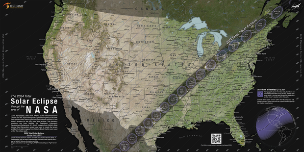
A total solar eclipse crosses North America on April 8, 2024, with parts of 15 U.S. states within the path of totality. Maps show where and when astronomy fans can see the big event.
The total eclipse will first appear along Mexico’s Pacific Coast at around 11:07 a.m. PDT, then travel across a swath of the U.S., from Texas to Maine, and into Canada.
About 31.6 million people live in the path of totality, the area where the moon will fully block out the sun, according to NASA. The path will range between 108 and 122 miles wide. An additional 150 million people live within 200 miles of the path of totality.
Solar eclipse path of totality map for 2024
The total solar eclipse will start over the Pacific Ocean, and the first location in continental North America that will experience totality is Mexico’s Pacific Coast, around 11:07 a.m. PDT on April 8, according to NASA. From there, the path will continue into Texas, crossing more than a dozen states before the eclipse enters Canada in southern Ontario. The eclipse will exit continental North America around 5:16 p.m. NDT from Newfoundland, Canada.
The path of totality includes the following states:
Small parts of Tennessee and Michigan will also experience the total solar eclipse.
Several major cities across the U.S. are included in the eclipse’s path of totality, while many others will see a partial eclipse. Here are some of the best major cities for eclipse viewing — if the weather cooperates:
- San Antonio, Texas (partially under the path)
- Austin, Texas
- Waco, Texas
- Dallas, Texas
- Little Rock, Arkansas
- Indianapolis, Indiana
- Dayton, Ohio
- Cleveland, Ohio
- Buffalo, New York
- Rochester, New York
- Syracuse, New York
- Burlington, Vermont
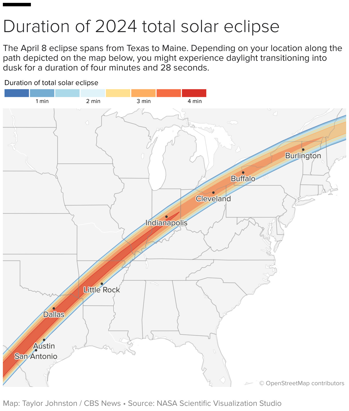
Map of when the solar eclipse will reach totality across the path
NASA
The eclipse will begin in the U.S. on the afternoon of April 8. NASA shared times for several cities in the path of totality across the U.S. You can also check your ZIP code on NASA’s map to see when the eclipse will reach you if you’re on, or near, the path of totality.
How much of the eclipse will you see if you live outside of the totality path?
While the April 8 eclipse will cover a wide swath of the U.S., many won’t see anything. Outside the path of totality, observers may spot a partial eclipse, where the moon covers most, but not all, of the sun, according to NASA.
NASA allows viewers to input a ZIP code and see how much of the sun will be covered in their location.
Where will the solar eclipse reach totality for the longest?
Eclipse viewers near Torreón, Mexico, will get to experience totality for the longest. Totality there will last 4 minutes, 28 seconds, according to NASA.
Most places along the centerline of the path of totality will see a totality duration between 3.5 and 4 minutes long, according to NASA. Some places in the U.S. come close to the maximum; Kerrville, Texas, will have a totality duration of 4 minutes, 24 seconds.
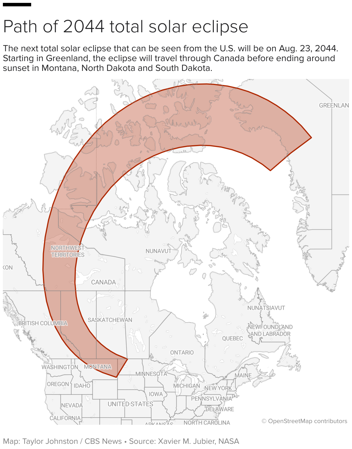
What is the path of totality for the 2044 solar eclipse?
After the April 8 eclipse, the next total solar eclipse that will be visible from the contiguous U.S. will be on Aug. 23, 2044.
Astronomy fans in the U.S. will have far fewer opportunities to see the 2044 eclipse than the upcoming one on April 8. NASA has not yet made maps available for the 2044 eclipse, but, according to The Planetary Society, the path of totality will only touch three states.
The 2024 eclipse will start in Greenland, pass over Canada and end as the sun sets in Montana, North Dakota and South Dakota, according to the Planetary Society.