(NEXSTAR) – Meteorologists say it’s too soon to give a precise forecast for the Christmas holiday. But in the meantime, we can look to the past for clues on who could see snow.
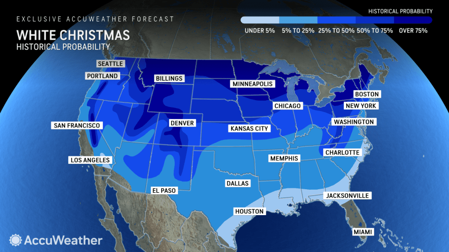
AccuWeather analyzed historical weather data between 1991 and 2020 to determine which areas of the country have the best odds of seeing a snowy Christmas. In the 25 largest U.S. cities, the odds are pretty slim at best.
Of the big cities, Denver and Chicago have the best probability of a white Christmas, based on historical data. AccuWeather gave them both about a 1 in 3 chance.
Indianapolis and Boston trail behind with about a 1 in 4 chance of seeing snow on Christmas, according to AccuWeather.
But the odds get better as you move north or to higher elevation. The organization released a map showing the whole country’s historical probability of seeing snow on the holiday. The far northern states and the mountainous areas of the West have the best chances, according to the map.
This year, the National Weather Service is anticipating La Niña will take hold in time for winter. The climate pattern could impact which parts of the country see more – or less – snow.
When NOAA meteorologist Tom Di Liberto recently reexamined snowfall trends during La Niña winters, he found they tend to be “banner years” for snow in the Pacific Northwest and the northern Rocky Mountains. The Great Lakes region and parts of New England also tend to see above-average snow when a La Niña pattern is in place, Di Liberto said.
But this year is expected to be a weak and shorter La Niña, which tends to have a slightly different impact on snowfall. The north-central U.S. sees even more snow during weak La Niña winters, and the Pacific Northwest isn’t quite as snowy as it would be during a strong La Niña.
AccuWeather is planning to release a more detailed Christmas snow forecast in mid-December. The National Weather Service’s Climate Prediction Center releases its outlooks for temperature and precipitation 6 to 10 days in advance.

